Creating a swale or berm on the site model surface
|
Tool |
Tool set |
|
Swale/Berm
|
Surface Sculpting |

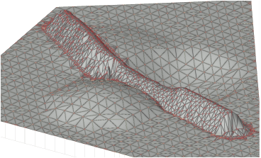
The Swale/Berm tool creates swales (depressions) or berms (mounds) on the site model, using a defined linear shape.

|
Mode |
Description |
|
Width |
Sets the width of the land feature at the point where it meets the site model surface |
|
Depth/Height |
Specifies the depth (for swales) or height (for berms); a negative value creates a swale, and a positive value creates a berm |
|
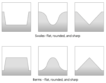
Profile |
Select a general shape for the land feature
|
|
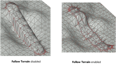
Follow Terrain
|
Toggles the ability of the elevation at the top of the land feature to either follow the elevation of terrain where it is placed, or simply to smoothly slope the top of the feature from starting to ending points of the polyline
|
|
Polyline creation options |
Selects the method for drawing the polyline upon which the swale or berm is based; see Creating polylines |

To create a swale or berm on the site model surface:
In site model Surface sculpting mode, click the tool.
Specify the size of the feature, and select a polyline mode. Select a Profile shape for the land feature, and toggle Follow Terrain on or off.
Not following the terrain could result in a swale that actually rises above the surrounding terrain in certain areas, or a berm that acts as a swale.
Draw the polyline to represent the swale or berm.
Double-click to finish drawing the feature.