 Calculating GradeCalculating Grade
The Grade tool annotates terrain slopes on site plan documents.
Networks of grade objects can be created to show slope characteristics across a surface. Grade objects can be used in conjunction with a site model, and can modify the site model. In addition, 3D loci can be generated from grade object elevations, and used as the basis of creating a site model.
The Grade tool has three modes:
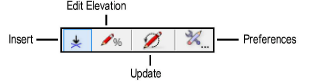
Mode |
Description |
|
Insert |
Draws a grade object based on set elevation parameters or a site model |
|
Edit Elevation |
Changes the elevation value of one or more existing grade objects |
|
Update |
Updates all grade objects in the drawing, applying current preference settings and updating any overlapped elevation points |
|
Preferences |
Sets the default global preferences for the grade object |
~~~~~~~~~~~~~~~~~~~~~~~~~
![]()