 Creating a Great CircleCreating a Great Circle
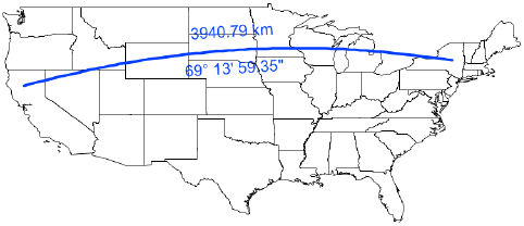
Use the Great Circle tool to place a great circle object over the drawing. Unlike a 2D dimension that shows the linear distance between X and Y coordinates in 2D, a great circle is an arc that shows the shortest distance between two points on the sphere-shaped Earth. Use the Great Circle tool (instead of a 2D dimension tool) to measure distances in a georeferenced drawing.
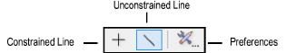
Mode |
Description |
Constrained Line |
Constrains the line to be vertical, horizontal, and 30° or 45° from vertical or horizontal in any direction |
Unconstrained Line |
Draws the line at any angle Press and hold the Shift key to snap the line to predetermined angles |
Preferences |
Sets the default parameters to be used for the tool |

To create a great circle:
From the Site Planning tool set, select the Great Circle tool.
From the Tool bar, click the Preferences button.
The Great Circle Properties dialog box opens.
Click to show/hide the parameters.
Click OK to save the default great circle settings.
From the Tool bar, select whether to use the Constrained Line or Unconstrained Line mode when drawing the great circle.
Click the drawing at the beginning point of the great circle, and click again at the ending point to create the object.
~~~~~~~~~~~~~~~~~~~~~~~~~
![]()