Searching
for the geolocationSearching
for the geolocation
Searching
for the geolocationSearching
for the geolocationMode |
Tool |
Workspace: Tool set |
Search
|
Geolocate
|
● Architect and Landmark: GIS ● Spotlight: Event Design |
Search mode searches for a general location, specific address, or coordinates, and sets the background image and optionally, the drawing’s internal origin to the selection. This allows you to specify the location that matches the drawing position or that best matches surveyor information.
1. Click the tool and mode.
The Search for Location dialog box opens.
![]() Click
to show/hide the parameters.
Click
to show/hide the parameters.
2. Enter a general location, such as a country, province, or state, or a specific location, such as an address or surveyor’s coordinates, and press Enter or click Search to display a list of possible results with the relevance based on the Search Options.
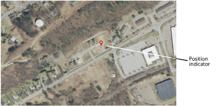
3. Click on a result (or multiple results) to see a preview of the map or satellite image centered in the drawing. A position indicator displays on the drawing. If multiple results are selected, each location is indicated, to assist with determining the correct one. Select only one location result for the geolocation, and click OK.
4. The location displayed in the preview remains in the view when the dialog box closes. If you selected Set the drawing origin at the selected location, the drawing’s internal origin is geolocated at the position indicator.
~~~~~~~~~~~~~~~~~~~~~~~~~