 Creating a site model from a boundaryCreating a site model from a boundary
|
Command |
Workspace: Path |
|
Site Model from Boundary |
● Architect: AEC > Terrain ● Landmark: Landmark > Create Site Model |
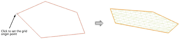
Create a flat, uniformly triangulated site model quickly from a closed 2D polygon or polyline, for shaping and sculpting.
To create a site model from a closed boundary:
1. Create the closed polygon or polyline with the 2D Polygon or Polyline tool.
2.Select the command.
The Site Model from Boundary dialog box opens.The Grid Spacing value determines the site model’s division into rows and columns, with each “cell” further divided into two triangular polygons. (Clipped cells may be subdivided unevenly.)
3.Specify the Grid Spacing value and click OK.
4.Click to set the grid origin point.
The Site Model Settings dialog box opens.
5.Specify the site model settings as described in Creating a site model from source data.
A flat site model is created based on the boundary shape. To shape it, sculpt it and/or edit its contours.
~~~~~~~~~~~~~~~~~~~~~~~~~