Creating property lines
Use the Property Line tool to draw property lines. Alternatively, use one of the following methods.
Draw a polyline and then select the Create Objects from Shapes command (see Creating objects from shapes).
Draw arcs and lines, select Modify > Compose to create a single polyline, and then select the Create Objects from Shapes command.
Property Line tool
|
Tool |
Tool set |
|
Property Line
|
Site Planning |

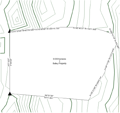
The Property Line tool interactively creates property boundaries from survey data. The resulting polyline is composed of line and/or arc segments. The closing segment can be automatically drawn and measured; each segment can be individually labeled with distance and bearing. Preformatted schedules provide information about property line segments and curves.

|
Mode |
Description |
|
Bearing and Distance
|
Draws a property line by sequentially specifying the bearing and distance of each linear or curved segment of the line |
|
Polyline
|
Draws a property line using the selected polyline creation options and the current preference settings (see Property line parameters) |
|
Polyline creation options |
For Polyline mode, selects the method for drawing the polyline upon which the object is based; see Creating polylines |
|
Preferences
|
Opens the object properties dialog box to set the default preferences for property lines |