Placing station points along the road polyline
|
Command |
Workspace: Path |
|
Station on Polyline |
Design Suite: AEC > Roads Landmark: Landmark > Roads |
The Vectorworks Landmark product places station points (stake objects) along the selected polyline at a specified interval.
To place station points:
Select the polyline, and then select the command.
The Place Station Points Along Polyline dialog box opens. This command places stations at 100’ (or 30.48 m) intervals. In addition, partial station points can be placed at smaller intervals. Enter the interval between partial stations and select a labeling option for the curve information.
Click to show/hide the parameters.Click to show/hide the parameters.
|
Parameter |
Description |
|
Partial station interval |
Indicates the spacing interval between partial station points |
|
Create individual curve labels |
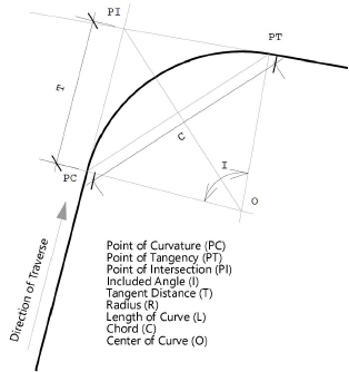
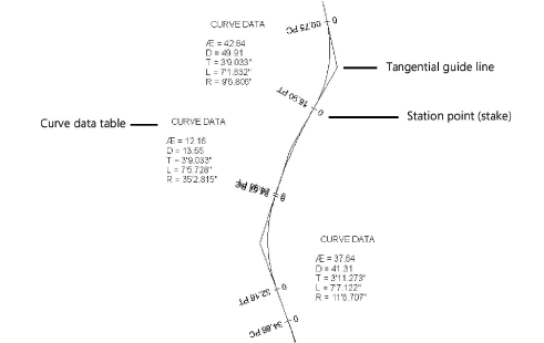
Creates curve data tables at each polyline curve. The curve labels include the following data:
|
|
Create circular curve data table |
Creates a Station Worksheet with the curve data; the worksheet number corresponds to the polyline number |
|
No Curve Data |
No curve data tables or tangent guide lines are created |
The first time you use the command in a file, a properties dialog box opens. Set the default parameters. The parameters can be edited later from the Object Info palette. Stake properties are described in Inserting stake objects.
Each station point is labeled. If curve data tables were created, they can be selected and moved if necessary.
The stakes have all been set to the elevation of the site model; the next step is to automatically set the road stake elevations as described in Setting stake elevations.