Creating a great circle
|
Tool |
Tool set |
|
Great Circle
|
GIS |

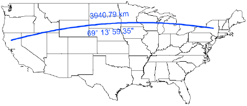
Use the Great Circle tool to place a great circle object over the drawing. Unlike a 2D dimension that shows the linear distance between X and Y coordinates in 2D, a great circle is an arc that shows the shortest distance between two points on the sphere-shaped Earth. Use the Great Circle tool (instead of a 2D dimension tool) to measure distances in a georeferenced drawing.
The Document Georeferencing dialog box opens if the document is not yet georeferenced, to select a coordinate system. See Specifying document georeferencing.

|
Mode |
Description |
|
Constrained Line
|
Creates a constrained line that is vertical, horizontal, and 30 degrees or 45 degrees from vertical or horizontal in any direction |
|
Unconstrained Line
|
Creates a line at any angle |
|
Preferences
|
Opens the Great Circle dialog box to set the default preferences for great circles |


To create a great circle:
Click the tool and mode.
Click Preferences to open the Great Circle Properties dialog box and specify the tool’s default parameters. The parameters can be edited later from the Object Info palette.
Click to show/hide the parameters.Click to show/hide the parameters.
|
Parameter |
Description |
|
Show Distance |
Places a distance measurement on the drawing |
|
Distance Unit |
Select the unit to use for the distance measurement |
|
Show Angle |
Places an angle measurement on the drawing |
|
Angle Format |
Select whether to use an azimuth or bearing format for the angle display |
|
Reverse |
Reverses the direction of the angle measurement |
Click the drawing at the beginning point of the great circle, and click again at the ending point to create the object.