 Creating
Grade Limits
Creating
Grade Limits
Creating
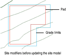
Grade LimitsGrade limits define the area of topographical transition between existing site data and the site modifiers enclosed within the grade limits; they can be thought of as a “limit of construction.” Outside the grade limits, the site remains unchanged; within the grade limits, the site model is defined by the pads. Grade limits can overlap, but cannot completely enclose, another grade limit area. Grade limits should not cross a pad or spoil pile.
Grade limits are created automatically around certain site modifiers, such as massing models. Grade limits can also be created automatically from pads (Vectorworks Landmark required). To draw grade limits manually, use the Site Modifiers tool, or draw a polyline and then select the Create Objects from Shapes command (see Creating Objects from Shapes).

To create grade limits:
Click the Site Modifiers tool from the Site Planning tool set, and click Grade Limits mode from the Tool bar.
Draw the grade limit area around a site modifier, such as a pad.
The properties can be edited from the Object Info palette.
► Click to show/hide the parameters.
To reflect the grade limit modification, select the site model and click Update from the Object Info palette.
~~~~~~~~~~~~~~~~~~~~~~~~~