 Adding a geolocated imageAdding a geolocated image
Tool |
Workspace: Tool set |
Geoimage
|
● Architect and Landmark: GIS ● Spotlight: Event Design |
The Geoimage tool places a portion of a map or other raster-based georeferenced image into the drawing. The image becomes a drawing object that persists after the tool is deselected, for reference or for incorporation into the final drawing.
Due to licensing restrictions, the image displays while working in the file, but it cannot be saved with the file for offline use unless you are logged in with an Esri account. Update the geoimage from the Object Info palette to download the image again, after saving the file.
The tool’s modes allow you to draw an area to create an image based on a service that may be different from the background image’s service. For example, you might need to include a soil map or hydrological map as a geoimage in the drawing. To navigate to the right location and determine where to draw the bounds of the geoimage, you can use a different service for the background imagery, one that provides context such as streets, labels, or lot lines.
The Document Georeferencing dialog box opens if the document is not yet georeferenced, to select a coordinate system. See Specifying document georeferencing.
While specifying the geoimage, the background imagery is scaled appropriately, and it updates when panning, zooming, and rotating the view; it displays as long as the tool is selected.
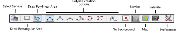
Mode |
Description |
Select Service |
Opens the Select Service dialog box, to specify the type of image to be created by the tool |
Draw Rectangular Area |
Draws a rectangular shape for the area |
Draw Polylinear Area |
Draws a polyline for the area |
Polyline Creation Options |
Selects the method for drawing the polyline upon which the object is based; see Creating polylines |
Display modes |
These four modes toggle to determine what displays while drawing the area with the tool |
No Background |
Does not display a background image |
Service |
Displays a matching image to the service selected with Select Service mode; use this mode to display the same background image as the geoimage |
Map |
Displays a map view |
Satellite |
Displays a satellite view |
Preferences |
Sets the default preferences for the geolocated image |
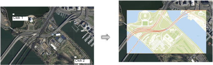
To draw an area and create a geoimage object:
1. Before using the Geoimage tool, first geolocate the drawing to obtain the desired location, by doing one of the following:
● Set specific location values in the Document Georeferencing dialog box; see Specifying document georeferencing
● Use the Geolocate tool for Geolocating the drawing and obtaining the desired location.
2. Click the tool.
3. The Geoimage tool captures an image according to the selected service and mode. Click Select Service mode to select the type of service to use for the geoimage (see Geolocating the drawing).
4. Click Preferences to set the image resolution options (and to edit the selected service, if needed).
The Geoimage Preferences dialog box opens.
![]() Click
to show/hide the parameters.
Click
to show/hide the parameters.
5. Select a display mode for the background image, which may be different from the geoimage’s display.
6. Select either Draw Rectangular Area or Draw Polylinear Area mode, depending on the geoimage shape required.
7. The geoimage is created.
When you select a different tool, the background image no longer displays, but the geoimage remains in the drawing.
The geoimage object can be cropped, clipped, reshaped, and moved. If it is moved, the object updates to display the correct portion of the map or image. The geoimage properties can be edited from the Object Info palette.
![]() Click
to show/hide the parameters.
Click
to show/hide the parameters.
~~~~~~~~~~~~~~~~~~~~~~~~~
