 Creating a hydrozoneCreating a hydrozone
Mode |
Tool |
Tool set |
Modes for the Polyline tool |
Hydrozone
|
Irrigation |
A hydrozone defines an area of grouped plants with similar water needs. A hydrozone is assigned a water-usage level and a general irrigation type. This is useful for landscape architects who want to add a generalized irrigation element to a planting plan, for designers creating a water-efficient planting plan that conforms to regulations, or for irrigation professionals who are in the early stages of a design. By defining the water needs of a landscape design, you can estimate the total water usage of a site. This can be useful for regulation and certification purposes. Predefined worksheets can report hydrozone area, water use, and plants categorized by water needs.
Place the hydrozone in a drawing with a site model, landscape area, or property line, and the calculations consider the Top/Plan site model area, property area, or landscape area, and determine the percentage of site area devoted to the hydrozone and its water usage requirements.
Mode |
Description |
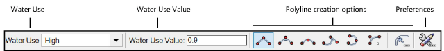
Water Use |
Specifies the water needs for the hydrozone area; select one of the predefined levels with a suggested value, or select Custom |
Water Use Value |
Displays the standard water use value (normally, a value between 0 and 1); a different value can be specified for any of the use levels. If this value is changed, the change affects future hydrozones, but not existing ones; the value is saved in the user folder. |
Polyline creation options |
Selects the method for drawing the polyline upon which the object is based; see Creating polylines |
Preferences |
Sets the default preferences for the hydrozone object |
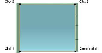
To create a hydrozone:
1. Click the tool and the polyline creation mode.
Alternatively, create a polyline and then select the Create Objects from Shapes command (see Creating objects from shapes).
2.Select the Water Use level and specify the Water Use Value for the zone.
3.Click Preferences to open the object properties dialog box and specify the tool’s default parameters. The parameters can be edited later from the Object Info palette.
![]() Click
to show/hide the parameters.
Click
to show/hide the parameters.
4.Click once to set the hydrozone location, and then draw the hydrozone polyline, clicking at each vertex. Click at the start point, or double-click, to finish drawing the hydrozone.
~~~~~~~~~~~~~~~~~~~~~~~~~
