Creating a contour
|
Mode |
Tool |
Tool set |
|
Contour
|
Site Modifiers
|
Site Planning |
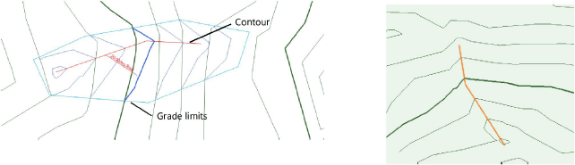
A contour is an open 3D polygon which modifies the site model, and represents a contour line at a constant elevation. The modifier can be applied to the existing or proposed site model; the site model is modified when the site model is updated. Draw a contour with the Site Modifiers tool, or draw a polyline and then select the Create Objects from Shapes command to change it to a pad object (see Creating objects from shapes).
The recommended method of creating and editing contours is by Editing site model contours.
To create a contour:
Click the tool and mode. Specify the pad elevation from the Tool bar if desired.
Draw the contour object.
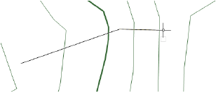
The parameters can be edited from the Object Info palette.
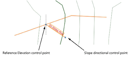
Normally, a contour site modifier does not have a slope since it indicates constant elevation. In rare cases when the modifier is sloping, specify the slope value; a slope arrow indicates the direction of the slope. The start of the slope arrow indicates the zero elevation point of the sloping contour. Select the control points of the slope arrow to move either end. Deselect Show Slope to hide the slope arrow.
Click to show/hide the parameters.Click to show/hide the parameters.
|
Parameter |
Description |
|
Simplification Tolerance |
Enter a positive value to redefine the horizontal distance between the closest parts of two neighboring portions of the modifier. A longer distance simplifies the modifier polygon, reducing the number of source points that modify the site model. A shorter distance increases the number of source points that modify the site model. A value of 0 (zero) does not simplify the modifier. |
|
Modifier Vertex Count |
Displays the number of vertices created by the site modifier to modify the site model |
|
Config |
Indicates the type of modifier object |
|
Elevation |
Sets the reference elevation of the pad at its control point; if a Z-height is also specified, the resulting elevation is additive |
|
Slope Def |
Select the method of defining a slope; typically, select None for a flat contour, which hides the slope parameters. If selecting a slope method, either specify the Slope or the Elevation at End of the slope, and the other value is automatically calculated and displayed. |
|
Slope |
Determines the slope of the modifier according to the selected slope definition method; enter the angle, percentage, or rise:run ratio |
|
Elevation at End |
Determines the slope by specifying the elevation of the modifier at the end of the slope; enter the elevation |
|
Apply To |
Specifies whether the site modifier applies to the existing or proposed site model |
|
Show Slope |
In rare cases when a contour line has a slope, displays a modifiable slope arrow and the current slope in Top/Plan view; Show Slope only displays if the slope is a value other than zero.
|
|
Vertex parameters |
Edits the path vertices; see Editing vertex-based objects |
Normally, create grade limits around the contour.
To reflect the contour modification, select the site model and click Update from the Object Info palette.