Geolocating the drawing
|
Tool |
Workspace: Tool set |
|
Geolocate
|
Architect and Landmark: GIS Spotlight: Event Design |

The Geolocate tool temporarily accesses background imagery from a map or satellite photography, to align the drawing’s internal origin with the image. This keeps the drawing’s geometry georeferenced to the proper part of the Earth. When your work is georeferenced and placed in the proper part of the world, it is kept close to the internal origin and the center of the drawing. This avoids precision errors; see Concept: Internal origin and user origin.
The Document Georeferencing dialog box opens if the document is not yet georeferenced, to select a coordinate system. See Specifying document georeferencing. Selecting an appropriate coordinate system is essential for the drawing distances to properly match the map distances.
The image is scaled appropriately, and it updates when panning, zooming, and rotating the view; it displays as long as the tool is selected.
The background image is temporary, and is no longer visible in the drawing when the tool is not selected. Use the Geoimage tool to incorporate the background image into the drawing.
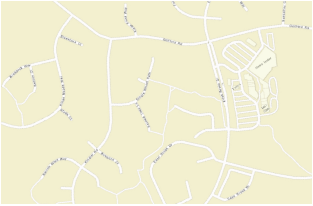
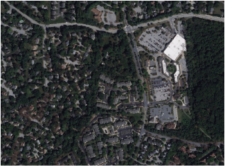
Select a map or a satellite view for the background image. The Geolocate tool toggles between these two types of view modes; one is always selected.
|
Mode |
Description |
|
Locate
|
Moves the background image to place the internal origin of the drawing on the appropriate point. This move affects all layers with georeferencing enabled, and they move along with the background image. All non-georeferenced layers remain about the internal origin. |
|
Rotate
|
Rotates the background image for alignment with the drawing geometry. This move affects all layers with georeferencing enabled, and they rotate along with the background image. All non-georeferenced layers remain about the internal origin. |
|
Search
|
Searches for the address, place, or coordinates, and displays the image at that location |
|
Map
|
Displays a map image (specify the type of map and service in the Preferences)
|
|
Satellite
|
Displays a satellite image (specify the type of satellite image and service in the Preferences)
|
|
Preferences
|
Opens the Geolocate Preferences dialog box |