Creating the road
|
Command |
Workspace: Path |
|
Create Road from Stakes |
Design Suite: AEC > Roads Landmark: Landmark > Roads |
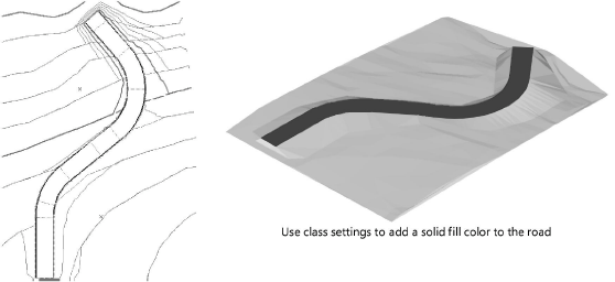
This procedure creates the road by automatically making a single polyline roadway, or by creating curved or straight road objects between each stake. The road follows the centerline polyline, and is set to the elevations specified by the stakes.
To create the road:
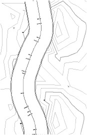
Select the center polyline or any of the station points, and select the command.
The Create Road from Stakes dialog box opens. Enter the road parameters.
Click to show/hide the parameters.Click to show/hide the parameters.
|
Parameter |
Description |
|
Select the result type |
|
|
A single Roadway (Poly) object |
Creates the road as a Roadway (Poly) object |
|
A set of Roadway (Curve) and Roadway (Straight) objects |
Creates the road as a series of curved and straight roadway objects along the stations |
|
Width |
Specifies the road width between the curbs |
|
Curb Height/Width |
Specifies the height and width of the road curbs |
|
Paving Thickness |
Sets the thickness of the road paving |
The polyline and stakes are used to create a Roadway (Poly) object, or a series of road sections between adjacent stakes.
The first time a road is created in a file, a properties dialog box opens. Set the default parameters. The parameters can be edited later from the Object Info palette.
If a single roadway was created, create a pad and grade limits for the roadway to modify the site model by selecting the options from the Object Info palette. See Creating polyline roadways.
If a set of straight and curved roads was created, the straight and curved sections of the road need to become site modifiers by selecting the road sections and then selecting Use Site Modifiers from the Object Info palette. Use the Custom Selection command to select the straight and curved road sections; see Creating custom selection scripts. The grade limits offset can be set manually, or the grade limits can be turned off and created separately using the Create Grade Limits from Planar Pad command (see Creating grade limits automatically). When site modifiers are used, each road section contains a pad (see Creating a planar pad or pad with retaining edge and Creating grade limits).
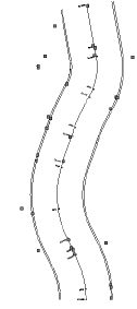
Stakes should not be moved (except in elevation) when using the Create Road from Stakes command. If an additional stake is required, add a vertex point to the polyline, provide an elevation value, and run the Create Road from Stakes command again.
The proposed site model requires updating. Select the site model and click Update from the Object Info palette.
If the road was created on a different layer from the site model, click Site Model Settings from the Object Info palette and ensure that Use Site Modifiers on includes the layer with the road.
The proposed site model is updated. If Use Site Modifiers is selected for the road sections, the contour lines are adjusted to rise or fall to meet the level of the road.