 Adding a GIS Stake
|
Mode |
Tool |
Tool set |
|
Standard Insertion
Vertex
GIS Stake Tool Preferences |
GIS Stake
|
GIS |


The GIS Stake tool is a modified version of the Stake tool found in the Site Planning tool set, with a few changes to the default settings to make it useful in a GIS workflow for reporting and validation, rather than for use on a site model.
Do not confuse the GIS Stake tool with the Survey Point tool. The GIS stake is more of an informational object, while the survey point sets a known point using a selected coordinate system, establishing the geographical location for the file.
The Geolocation dialog box can be accessed from the GIS Stake Tool Preferences on the Tool bar, to select a coordinate system if the file is not yet geolocated. See Specifying georeferencing and geolocation.
To insert one or more GIS stakes:
Before using the GIS Stake tool, geolocate the file.
Click the tool and an insertion mode. Standard Insertion places a single GIS stake object, while Vertex mode places a GIS stake at each clicked polyline vertex.
Do one of the following:
Click once to place a stake in Standard Insertion mode.
In Vertex mode, click to set vertices, placing a stake at each vertex. Double-click to stop placing stakes.
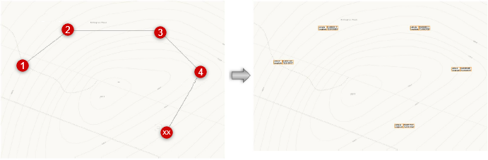
In Vertex mode, each click places a stake. In this example of five stakes placed, a topographic map was selected for the service.
If you know the exact coordinates for the stake object, click Set Geolocation from the Object Info palette of a selected GIS stake to move it.
The Set Geographical Location dialog box opens; enter the desired stake coordinates. Changing these doesn’t affect the geolocation of the project; it only moves the stake to the specified coordinates.
Click to show/hide the parameters.Click to show/hide the parameters.
|
Parameter |
Description |
|
Specify geographical coordinates / Specify geographical (WGS-84) coordinates |
Specifies the stake location according to geographical or geographical (WGS-84) coordinates |
|
Latitude/Longitude |
Specifies the latitude and longitude at the document origin (0,0); enter decimal degrees, or degrees/minutes/seconds (for example, 39.18, 39° 10' 32", or 39d 10m 32s) preceded by a minus (-) sign when appropriate |
|
Specify Cartesian coordinates |
Specifies the stake coordinates according to Cartesian coordinates, Easting and Northing; enter the coordinates in meters or feet, according to the selected file coordinate system. Precision values are always set to eight positions past the decimal point, regardless of the document unit settings. |
See Inserting stake objects for information about stake parameters. The GIS Stake tool has certain parameter presets, since its primary purpose is to provide location data.
The stake Mode is: Use as 2D/3D graphic only.
The object's Label Reference parameter defaults to Coordinate Point (NE) to correspond with the convention of locating points according to their latitude and longitude values. In addition, both Coordinate Point (NE) and Coordinate Point (EN) show values from the coordinate system. Latitude/Longitude and Longitude/Latitude are also available.
The Label Reference of Coordinate Point (XY) reports the user origin coordinates.
The Coordinate Units parameter defaults to decimal degrees. If using a Label Reference of Coordinate Point (XY), change the value to CRS Units, document units, feet, or meters. NE should always be in CRS Units, meters, or feet. Lat/Long use decimal degrees.
