Calculating and displaying grade and elevation
|
Tool |
Workspace: Tool set |
|
Grade
|
Design Suite, Architect, Spotlight: Building Shell Landmark: Site Planning and Dims/Notes |

The Grade tool is available in all Vectorworks Design Suite products, but its site model functionality requires additional features that are available only in the Landmark and Architect products.
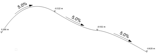
When used for site planning, the Grade tool annotates terrain slopes on site plan documents. It can also be used to analyze slopes in the drawing and identify critical slopes that need attention; see Grade settings: Analysis pane.
Networks of connected grade objects can be created to show elevation and slope characteristics across a surface. Grade objects can be used in conjunction with a site model (automatically picking up the elevation from the site model), and can modify the site model. If the site model does not yet exist, 3D loci can be generated from grade object elevations, and those can then be used as the basis of creating a site model.
|
Mode |
Description |
|
Vertex
|
Draws a grade using the selected polyline creation options and the current preference settings |
|
Linear Insertion
|
Draws a grade based on set elevation parameters or a site model |
|
Edit Elevation
|
Changes the elevation value of one or more existing grade objects |
|
Polyline creation options |
For Vertex mode, selects the method for drawing the object's path polyline |
|
Parameter 1/Parameter 2 |
Given two parameters, the grade parameters are calculated for the remaining parameters; select the two known parameters for the grade being drawn. See Grade settings: General pane. |
|
Review and Adjust
|
For Linear Insertion mode, opens the Grade Settings dialog box after creation of a grade line |
|
Update
|
Updates all grade objects in the drawing, applying current preference settings and updating any overlapped elevation points |
|
Preferences
|
Sets the default global preferences for the grade object |